Showing posts with label LRO. Show all posts

Wednesday, March 26, 2014

What is LROC?

[NASA/GSFC/Arizona State University].
LROC Northern Polar Mosaic (LNPM)
The LROC team assembled 10,581 NAC images, collected over 4 years, into a spectacular northern polar mosaic. The LROC Northern Polar Mosaic (LNPM) is likely one of the world’s largest image mosaics in existence, or at least publicly available on the web, with over 680 gigapixels of valid image data covering a region (2.54 million km2, 0.98 million miles2) slightly larger than the combined area of Alaska (1.72 million km2) and Texas (0.70 million km2) -- at a resolution of 2 meters per pixel! To create the mosaic, each LROC NAC image was map projected on a 30 m/pixel Lunar Orbiter Laser Altimeter (LOLA) derived Digital Terrain Model (DTM) using a software package called the Integrated Software for Imagers and Spectrometers (ISIS). SEE: What is LROC

***

See Also:


Tuesday, August 28, 2012

Grail At the Moon


 Grail Recovery and Interior Labratory
NASA's Gravity Recovery And Interior Laboratory (GRAIL)-A spacecraft successfully completed its planned main engine burn at 2 p.m. PST (5 p.m. EST) today. As of 3 p.m. PST (6 p.m. EST), GRAIL-A is in a 56-mile (90-kilometer) by 5,197-mile (8,363-kilometer) orbit around the moon that takes approximately 11.5 hours to complete.


Visualisation of the “Geoid” of the Moon

Sunday, July 15, 2012

Space Geodesy


 Project manager Stephen Merkowitz talks about his work with NASA's Space Geodesy Project, including a brief overview of the four fundamental techniques of space geodesy: GPS, VLBI, SLR, and DORIS.

Learn more about space geodesy at: http://space-geodesy.nasa.gov/

This video is public domain and can be downloaded at: http://svs.gsfc.nasa.gov/goto?11031


Space Geodesy provides positioning, navigation, and timing reference systems and Earth system observations
Geodesy is the science of the Earth’s shape, gravity and rotation, including their evolution in time. A number of different techniques are used to observe the geodetic properties of the Earth including the space-geodetic techniques of Very Long Baseline Interferometry (VLBI), Satellite Laser Ranging (SLR), Global Navigation Satellite Systems (GNSS) like the US Global Positioning System (GPS), and the French Doppler Orbitography and Radio-Positioning by Integrated Satellite (DORIS) system. These space-geodetic observations also provide the basis for the reference frame that is needed in order to assign coordinates to points and objects and thereby determine how those points and objects move over time. See SGP Science


See Also:


Saturday, October 08, 2011

Subtly Shaded Map of Moon Reveals Titanium Treasure Troves

A map of the Moon combining observations in visible and ultraviolet wavelengths shows a treasure trove of areas rich in Titanium ores. Not only is Titanium a valuable mineral, it is key to helping scientists unravel the mysteries of the Moon’s interior.  Mark Robinson and Brett Denevi will be presenting the results from the Lunar Reconnaissance Orbiter mission today at the joint meeting of the European Planetary Science Congress and the American Astronomical Society’s Division for Planetary Sciences. >EPSC-DPS JOINT MEETING 2011 PRESS NOTICE
ISSUED 13:15 CEST ON FRIDAY 7TH OCTOBER
Ref. PN: EPSC11/14
 

It seems this Europlanet is a little bit behind the times. Check label below on Plato's Nightlight Mining Company. What more can I say?

See Also: LROC “Treasure Map” Reveals Titanium Deposits

Monday, April 25, 2011

LRO's Crater Science Investigations


If you want to learn more about the history of Earth and other rocky planets in the solar system, craters are a great place to look. Now, thanks to LRO's LROC instrument, we can take a much closer look at Linné Crater on the moon--a pristine crater that's great to use to compare with other craters! See: LRO's Crater Science Investigations


The life cycle of a lunar impact and associated time and special scales. The LCROSS measurement methods are “layered” in response to the rapidly evolving impact environment. See: Impact:Lunar CRater Observation Satellite (LCROSS)


Data from the ultraviolet/visible spectrometer taken shortly after impact showing emission lines (indicated by arrows). These emission lines are diagnostic of compounds in the vapor/debris cloud.
Credit: NASA


LCROSS Impact Data Indicates Water on Moon11.13.09


 ***
 

It is important that we establish an outpost on the moon in order to progress further out into the universe. A lot of work has to be done to venture further out, so that we may explore.

Click on Image


See Also: Plato's Nightlight Mining Company

Sunday, November 14, 2010

The Lunar Far Side: The Side Never Seen from Earth

                                                            Mass concentration (astronomy)

This figure shows the topography (top) and corresponding gravity (bottom) signal of Mare Smythii at the Moon. It nicely illustrates the term "mascon". Author Martin Pauer

While article is from Tuesday, June 22, 2010 9:00 PM it still amazes me how we see the moon in context of it's coloring.
Topography when seen in context of landscape, how we measure aspects of the gravitational field supply us with a more realistic interpretation of the globe as a accurate picture of how that sphere(isostatic equilibrium)  looks.


Image Credit: NASA/Goddard
Ten Cool Things Seen in the First Year of LRO

Tidal forces between the moon and the Earth have slowed the moon' rotation so that one side of the moon always faces toward our planet. Though sometimes improperly referred to as the "dark side of the moon," it should correctly be referred to as the "far side of the moon" since it receives just as much sunlight as the side that faces us. The dark side of the moon should refer to whatever hemisphere isn't lit at a given time. Though several spacecraft have imaged the far side of the moon since then, LRO is providing new details about the entire half of the moon that is obscured from Earth. The lunar far side is rougher and has many more craters than the near side, so quite a few of the most fascinating lunar features are located there, including one of the largest known impact craters in the solar system, the South Pole-Aitken Basin. The image highlighted here shows the moon's topography from LRO's LOLA instruments with the highest elevations up above 20,000 feet in red and the lowest areas down below -20,000 feet in blue.

Learn More About Far side of the Moon

***
 Credit: NASA/Goddard/MIT/Brown

Figure 4: A lunar topographic map showing the Moon from the vantage point of the eastern limb. On the left side of the Moon seen in this view is part of the familiar part of the Moon observed from Earth (the eastern part of the nearside). In the middle left-most part of the globe is Mare Tranquillitatis (light blue) the site of the Apollo 11 landing, and above this an oval-appearing region (Mare Serenitatis; dark blue) the site of the Apollo 17 landing. Most of the dark blue areas are lunar maria, low lying regions composed of volcanic lava flows that formed after the heavily cratered lunar highlands (and are thus much less cratered). The topography is derived from over 2.4 billion shots made by the Lunar Orbiter Laser Altimeter (LOLA) instrument on board the NASA Lunar Reconnaissance Orbiter. The large near-circular basins show the effects of the early impacts on early planetary crusts in the inner solar system, including the Earth. 

***
 Author and Image Credit: Mark A. Wieczorek
Radial gravitational anomaly at the surface of the Moon as determined from the gravity model LP150Q. The contribution due to the rotational flattening has been removed for clarity, and positive anomalies correspond to an increase in magnitude of the gravitational acceleration. Data are presented in two Lambert azimuthal equal area projections.
The major characteristic of the Moon's gravitational field is the presence of mascons, which are large positive gravity anomalies associated with some of the giant impact basins. These anomalies greatly influence the orbit of spacecraft about the Moon, and an accurate gravitational model is necessary in the planning of both manned and unmanned missions. They were initially discovered by the analysis of Lunar Orbiter tracking data,[2] since navigation tests prior to the Apollo program experienced positioning errors much larger than mission specifications.

Friday, November 13, 2009

LCROSS Observes Water on Moon


Data from the ultraviolet/visible spectrometer taken shortly after impact showing emission lines (indicated by arrows). These emission lines are diagnostic of compounds in the vapor/debris cloud.
Credit: NASA


LCROSS Impact Data Indicates Water on Moon11.13.09


The argument that the moon is a dry, desolate place no longer holds water.

Secrets the moon has been holding, for perhaps billions of years, are now being revealed to the delight of scientists and space enthusiasts alike.

NASA today opened a new chapter in our understanding of the moon. Preliminary data from the Lunar CRater Observation and Sensing Satellite, or LCROSS, indicates that the mission successfully uncovered water during the Oct. 9, 2009 impacts into the permanently shadowed region of Cabeus cater near the moon’s south pole.

The impact created by the LCROSS Centaur upper stage rocket created a two-part plume of material from the bottom of the crater. The first part was a high angle plume of vapor and fine dust and the second a lower angle ejecta curtain of heavier material. This material has not seen sunlight in billions of years.

See more on link above.


LRO's First Moon Images

07.02.09

1994 Clementine image of moon with Mare Nubium labeled 
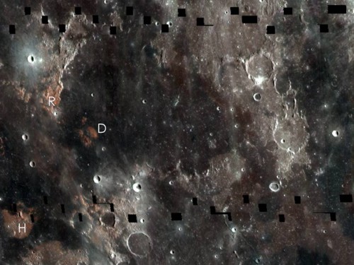
1994 Clementine image of the moon with Mare Nubium labeled. LRO's first lunar images show an area near this region. Credit: NASA

NASA's Lunar Reconnaissance Orbiter has transmitted its first images since reaching the moon on June 23. The spacecraft's two cameras, collectively known as the Lunar Reconnaissance Orbiter Camera, or LROC, were activated June 30. The cameras are working well and have returned images of a region in the lunar highlands south of Mare Nubium (Sea of Clouds).

As the moon rotates beneath LRO, LROC gradually will build up photographic maps of the lunar surface.

"Our first images were taken along the moon's terminator -- the dividing line between day and night -- making us initially unsure of how they would turn out," said LROC Principal Investigator Mark Robinson of Arizona State University in Tempe. "Because of the deep shadowing, subtle topography is exaggerated, suggesting a craggy and inhospitable surface. In reality, the area is similar to the region where the Apollo 16 astronauts safely explored in 1972. While these are magnificent in their own right, the main message is that LROC is nearly ready to begin its mission."